
News
SSAI’s Colin Seftor uses Aerosol Index data to study impact of Saharan Dust Storms this Spring
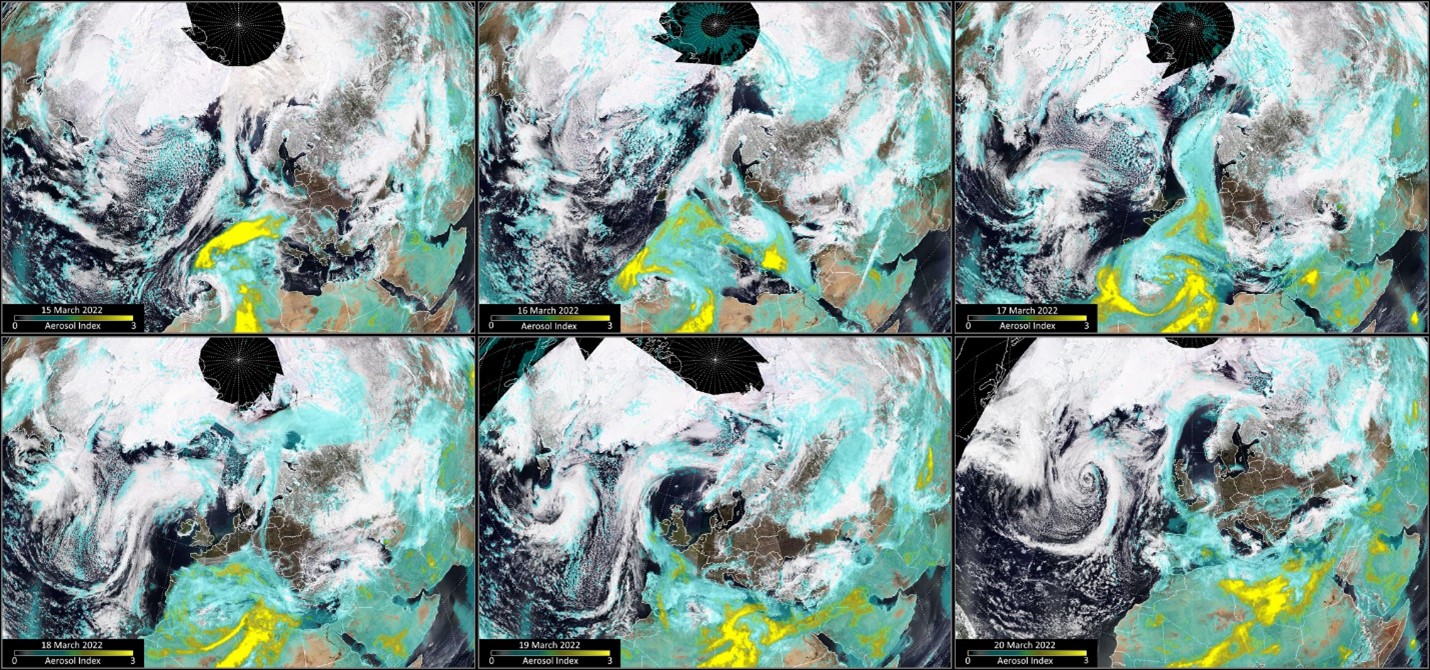
Saharan dust covered many parts of Europe in March of this year. Although it’s not unusual to see Saharan dust storms moving across Europe during the northern hemisphere spring season, this particular event was an unusual type of storm that until recently had not been well understood. Called a Dust-Infused Baroclinic Storm (DIBS), such storms contain icy clouds permeated with dust.
An atmospheric river of Saharan dust was entrained by the DIBS and lifted into the troposphere, reaching altitudes up to 10 kilometers (6 miles). The dust acted as nucleation particles for ice, leading to the formation of icy high-altitude, dust-infused cirrus clouds.
To help study this event, Mike Fromm, a meteorologist with the Naval Research Lab, reached out to SSAI’s Colin Seftor, an expert in the use of a satellite data product known as the Aerosol Index (AI). The AI, which Colin helped develop, uses UV measurements to detect and track the movement of atmospheric aerosols such as smoke, dust, and volcanic ash. A unique ability of the AI is the detection of such aerosols on top of, and inter-mixed with, clouds, making it ideal for studying such events.
Mike was able to determine that two different DIBS were formed, which is notable in that it is more common to see a single storm arise from an influx of dust.
The first storm started on March 15, 2022 over north central Europe and spread from Poland, Czechia, and Austria south to the eastern Mediterranean. This was also unusual, Mike said, as there is “usually a direct connection of a DIBS to its dry dust source, closer to the desert itself.”
On March 16, a second storm followed the classic pattern, spinning up closer to the source of the dust in Africa. The large, widespread dust cloud continued moving north over Europe toward Scandinavia and the Arctic Ocean. It then moved east over northern Russia before taking an anticyclonic turn and curving back down into Eastern Europe and the Black Sea region on March 20.
In late March, yet another large dust storm started making its way north carrying Saharan dust over the Mediterranean and Europe.
According to Colin, “Two large [storms] like this almost back-to-back is somewhat unusual, but the weather patterns over northern Africa and Europe during the spring seem to be more conducive to producing dust storms that reach Europe than at other times of the year.”
Learn more here: Dusty Storm Clouds Over Europe (nasa.gov)