
Success Stories
SSAI Enhances Worldview Visualizations to Improve Discoverability, Accessibility, and Useability of NASA Earth Science Data and Imagery
The SSAI- and ASRC-staffed Worldview Team implemented a series of visual and interactive enhancements for the 900+ imagery products offered through NASA's Global Imagery Browse Services (GIBS).
As the GIBS team expands the visualization services and products provided through GIBS, Worldview must continuously keep pace by providing features to better access and visualize these products.
Overview
NASA's Worldview is an open-source imagery visualization application that provides the capability to interactively browse NASA’s Earth science data and imagery. Many of the imagery layers are available in near real-time, within three hours of observation, and are updated daily with imagery going back a few decades. Worldview uses NASA's Global Imagery Browse Services (GIBS) to rapidly retrieve its imagery for an interactive browsing experience. Both the GIBS and Worldview Teams are staffed with SSAI and ASRC team members. As the GIBS team is constantly expanding the visualization services and products provided through GIBS, Worldview must continuously keep pace by providing features to better access and visualize these products. Recently, the Worldview team implemented a series of improvements in order to increase the discoverability, accessibility, and usability of the tool for the end user.
Results
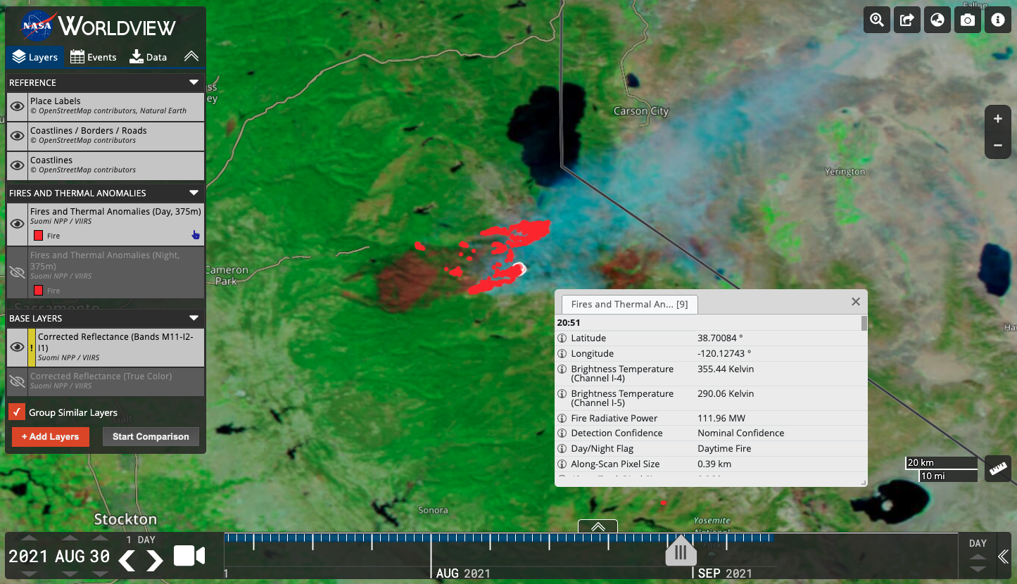 In coordination with the GIBS team and data providers, the Worldview team transitioned a selection of visualization products from raster imagery to vector data visualization. This enhancement enabled associated attribute information in the imagery to be obtained by the user. For example, users are now able to interact with vector data, such as the fire and thermal anomalies layers (pictured right), based on where the image is on the page], and obtain fire radiative power, detection confidence, and brightness temperature at a specific point.
Furthermore, the GIBS and Worldview Teams delivered the highly anticipated 30-meter spatial resolution Harmonized Landsat Sentinel-2 (HLS) Project layers. This imagery exhibits a spatial resolution 8 times higher than the existing daily, global imagery displayed by Worldview, and therefore provides a high-resolution view of the earth’s surface.
The Worldview team also implemented interface changes to increase the visualization products’ discoverability and usage, including the addition of: 1) An improved layer picker to facilitate visualization product searches. This enhancement allows for faceted filtering, where the visualization layers can be filtered by measurement, temporal period, satellite/sensor combination, and much more; 2) A temporal availability panel to enable users to visually determine the date availability of layers loaded in Worldview and to find occurrences of temporally coincident imagery; 3) A tour story feature that offers curated stories and tutorials, which demonstrate how to use Worldview and provides examples of Worldview use cases; and 4) A redesigned data download option that enables users to directly access data in the visualization products via the Common Metadata Repository (CMR) and Earthdata Search tool.
Looking to the future, GIBS and Worldview are supporting artificial intelligence/machine learning analysis of imagery through the SpaceML initiative developed by the NASA-supported Frontier Development Lab. The aforementioned enhancements in combination with this initiative and follow-on work significantly benefit users of the vast set of visualizations available through GIBS and Worldview. SSAI is thrilled to be a part of the transformation of this tool.