
Success Stories
SSAI Leverages Machine Learning to Obtain Accurate Satellite Retrievals
SSAI’s Ozone Monitoring Instrument (OMI) Team uses machine learning to circumvent interference from clouds, aerosols, and sunglint during satellite retrievals.
Results showed that the machine learning based approach from OMI provides similar retrievals to that of MODIS but with improved spatial coverage; as this new approach allows for retrievals in less-than-ideal conditions, due to the presence of clouds, aerosols, and sunglint.
Overview
Interference from clouds, aerosols, and strong water surface reflection known as sunglint are major obstacle for obtaining accurate satellite retrievals. Thus, the SSAI OMI team set out to develop new techniques to mitigate this challenge using machine learning. In summary, a principal components analysis was used to decompose hyperspectral measurements into principal components that statistically describe the variations in the spectral measurements due to scattering/absorption of the atmosphere and underlying surface. These principal components were then used as inputs to a neural network and trained to retrieve atmospheric and surface properties.
Results
Satellite retrieval of ocean properties is one of many use cases that may benefit from this approach. As such, the SSAI OMI team focused on chlorophyll—the main food source for small organisms, like phytoplankton, in the ocean. Essentially, the SSAI OMI team used ultraviolet and visible measurements from OMI to develop a machine learning based model for retrieving chlorophyll. Since the OMI instrument does not produce any ocean color products, MODIS ocean color retrievals were used to train the model.
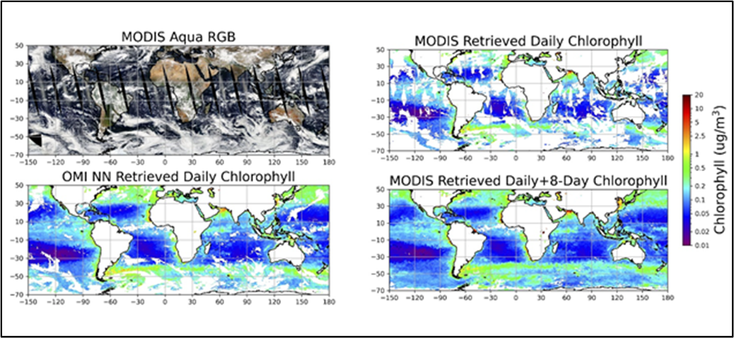 Top left - is the MODIS Aqua RGB image
Bottom left - OMI machine learning based chlorophyll retrieval
Top right - MODIS retrieved daily chlorophyll
Bottom right - MODIS daily chlorophyll retrieval gap-filled with the MODIS 8-day chlorophyll composite product.
Results showed that the machine learning based approach from OMI provides similar retrievals to that of MODIS but with improved spatial coverage; as this new approach allows for retrievals in less-than-ideal conditions, due to the presence of clouds, aerosols, and sunglint. Because the improvements offered by this methodology have been so clearly demonstrated, these techniques will be applied to existing instruments—such as the TROPOspheric Monitoring Instrument (TROPOMI) and the Geostationary Environment Monitoring Spectrometer (GEMS); as well to instruments with upcoming launches—including the Plankton, Aerosol, Cloud, and ocean Ecosystem (PACE) satellite and the Tropospheric Emissions Monitoring of POllution (TEMPO) instrument. In the meantime, the SSAI OMI team continues to work on developing this new approach in order to further improve satellite retrieval capabilities.