
Success Stories
SSAI Targets Science for Societal Benefit
NASA’s Black Marble product, which is developed, maintained, and managed by the Black Marble science team, including SSAI scientist Dr. Ranjay M. Shrestha, is actively used by multiple government and scientific agencies to measure the impacts of natural disasters on the electricity grid, monitor the effects of conflict and population displacement, map out urbanization, track electrification and light pollution, and understand activity patterns within human settlements.
Our SSAI scientist plays a critical role on the Black Marble science team in maintaining the quality of the product, curating the website for the latest product updates, providing end-user training and support, and developing special products and images for disaster response and outreach efforts.
Overview
NASA’s Black Marble nighttime lights product suite (VNP46) is derived from the Visible Infrared Imaging Radiometer Suite (VIIRS) Day/Night Band (DNB) onboard the Suomi National Polar-orbiting Platform (SNPP). The product is routinely made available through the NASA Level 1 and Atmosphere Archive and Distribution System (LAADS) Distributed Active Archive Center (DAAC). The Black Marble science team developed the NASA Black Marble algorithm to convert raw imagery into science-quality cloud-free daily global nighttime light data that has been corrected for non-anthropogenic light sources (e.g., moonlight, airglow, auroras), atmospheric constituents (e.g., dust, haze, cloud), and surface reflection effects (e.g., snow, fire, vegetation cover).
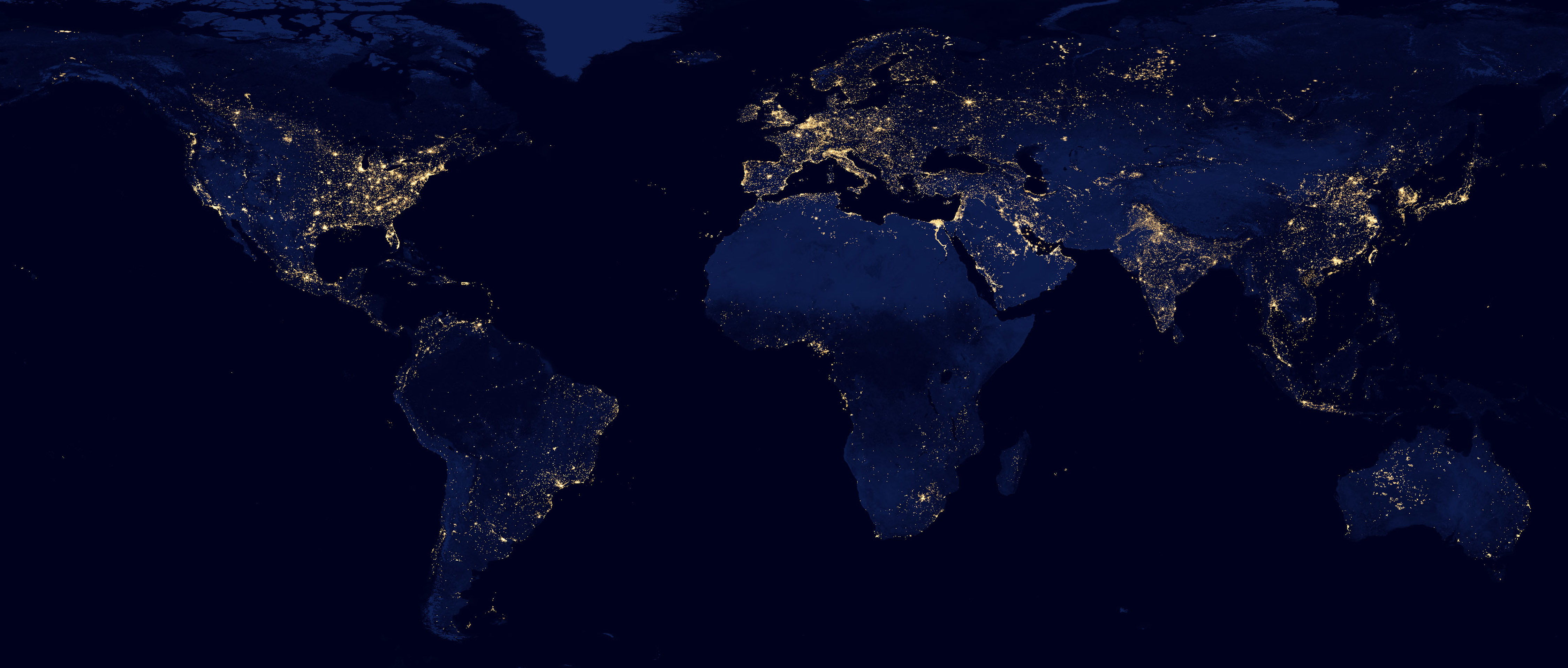 These corrections provide superior retrieval of nighttime light observations enabling quantitative analyses of daily, seasonal, and annual variations of outdoor lighting on a global scale. The standard (Level 3 daily) and multi-date composite products are available at 500 m spatial resolution from January 2012 to present. The standard products are being processed daily, within 3-5 hours after acquisition, and can be utilized as an efficient tool for both rapid assessments and long-term monitoring.
Results
The product is being routinely generated to enable near-real-time applications of the data, in addition to long-term fundamental research.
The product suite has been used to assess disruptions in energy infrastructure and utility services following major disasters, as well as to track progress as these services are slowly restored. Examples include but are not limited to: Hurricane Maria in Puerto Rico (2017), Hurricanes Florence and Michael in North Carolina and Florida, respectively (2018); as well as Cyclone Idai, Cyclone Fani, and Hurricane Dorian in Mozambique, India, and the Bahamas (2019), respectively. Subsequently, the data was used to analyze the relationship between restoration rates in terms of days without electricity and the remoteness of communities from major cities. Notably, during Hurricane Florence, soldiers at the U.S. Army’s Fort Bragg facility were able to obtain the pre-and post-event mapping of Black Marble power outage images directly from their cell phones and use them to assess power outages on their army base. These rapid assessment maps were available to soldiers in near-real-time and allowed the base to maintain security despite the outages.
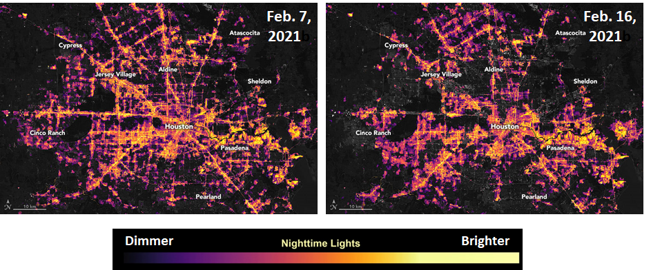
In addition, the product also played an integral role in producing power outage maps during the unprecedented Texas winter storm of 2020-2021, where the outage spanned the entire state of Texas - the only state in the US that has isolated its power grid from the rest of the country.
 In the context of research, the Black Marble product has also been instrumental in assessing human-driven patterns, allowing researchers to gain a new perspective on the impacts of human activity on Earth. Scientists can tell not only where infrastructure is, but how frequently various parts are being used and how human settlements are growing and changing over time. This allows scientists to tackle important questions surrounding urbanization, such as whether cities are becoming more or less sustainable, how they are consuming resources, and what drives human movement around the globe.
 Most recently, Black Marble has been used to monitor the impacts of the ongoing global COVID-19 pandemic. During the beginning stages of the outbreak, the Black Marble product-derived images were able to capture the shutdown impact of businesses and transportation in Wuhan - ground zero of the outbreak - and around the Hubei province in central China. Black Marble was also one of the four research projects selected/funded for the study on COVID-19 impacts through NASA’s Rapid Response and Novel Research in Earth Science (RRNES) initiative. Furthermore, Black Marble was included as one of the socio-economic indicators in the tri-agency COVID-19 Dashboard - a concerted effort between the European Space Agency (ESA), Japan Aerospace Exploration Agency (JAXA), and NASA. The dashboard combines the resources, technical knowledge, and expertise of the three partner agencies to strengthen our global understanding of the environmental and economic effects of the COVID-19 pandemic. The nighttime light observations were employed to track socio-economic indicators by providing information about variations in energy use, migration, and transportation in response to social distancing and lockdown measures.
Given the societal benefits and research applications Black Marble has to offer, SSAI is proud to be part of the various aspects of its success. Our SSAI scientist plays a critical role on the Black Marble science team in maintaining the quality of the product, curating the website for the latest product updates, providing end-user training and support, and developing special products and images for disaster response and outreach efforts. SSAI is honored to be contributing to such a valuable project and looks forward to extending our support well into the future.